|
Majority Minority Review 3
Housing and Religion in
Northern Ireland
by Martin Melaugh
Appendices
Appendix 3.1: Aspects of housing characteristics,
district council areas, 1971
| Councils | % Catholics 1971(based on adjustments by Compton, 1978)
| Number of private households
| % dwellings owner-occupied
| % dwellings public rented
| Average number of persons per room
| % households living at a density of more than 1.0 persons per room
|
| Antrim | 31.10
| 8740
| 34.77
| 53.10
| 0.73
| 15.40
|
| Ards | 16.00
| 14427
| 41.41
| 41.08
| 0.63
| 9.91
|
| Armagh | 44.50
| 12101
| 50.19
| 35.42
| 0.73
| 18.85
|
| Baiiymena | 17.70
| 13756
| 52.96
| 32.45
| 0.67
| 12.68
|
| Ballymoney | 29.60
| 5734
| 39.65
| 50.46
| 0.77
| 22.62
|
| Banbridge | 31.20
| 8135
| 48.19
| 34.00
| 0.72
| 16.98
|
| Belfast | 34.10
| 125388
| 43.28
| 25.49
| 0.65
| 13.94
|
| Carrickfergus |
16.20
| 7823
| 31.39
| 56.70
| 0.65
| 9.33
|
| Castlereagh | 10.10
| 18280
| 52.25
| 42.26
| 0.65
| 7.37
|
| Coleraine | 23.90
| 12132
| 45.95
| 37.85
| 0.67
| 14.93
|
| Cookstown | 49.20
| 6705
| 58.15
| 29.41
| 0.80
| 23.49
|
| Craigavon | 38.70
| 18887
| 31.85
| 51.67
| 0.70
| 14.72
|
| Down | 54.10
| 12323
| 47.31
| 33.66
| 0.74
| 19.78
|
| Dungannon | 52.30
| 10961
| 53.15
| 32.87
| 0.79
| 23.12
|
| Fermanagh | 52.50
| 13458
| 60.87
| 24.86
| 0.75
| 20.62
|
| Larne | 26.80
| 8574
| 40.96
| 42.32
| 0.64
| 10.81
|
| Limavady | 52.40
| 5575
| 34.84
| 44.38
| 0.89
| 28.61
|
| Lisburn | 16.60
| 20295
| 48.76
| 36.97
| 0.65
| 10.47
|
| Derry | 64.30
| 19611
| 38.77
| 45.10
| 0.85
| 26.85
|
| Magherafelt | 54.70
| 7730
| 53.75
| 33.64
| 0.85
| 26.75
|
| Moyle | 48.70
| 3676
| 47.78
| 39.45
| 0.74
| 20.92
|
| Newry & Mourne
| 71.40
| 18356
| 47.21
| 41.25
| 0.81
| 25.10
|
| Newtownabbey |
18.00
| 19240
| 43.18
| 42.26
| 0.67
| 8.79
|
| North Down | 11.30
| 16921
| 62.82
| 22.82
| 0.55
| 5.42
|
| Omagh | 62.10
| 10112
| 57.51
| 28.28
| 0.81
| 24.60
|
| Strabane | 56.90
| 8494
| 45.58
| 36.23
| 0.86
| 29.81
|
| Northern Ireland |
36.80
| 427434
| 45.94
| 34.76
| 0.70
| 15.89
|
(Continued below)
Appendix 3.1: Aspects of housing characteristics, continued
| Councils | % dwellings with exclusive use of hot water, fixed bath, and inside WC
| % dwellings with exclusive use of hot water
| % dwellings with exclusive use of fixed bath
| % dwellings with exclusive use of inside WC
| % households employed in farming
|
| Antrim | 80.8
| 84.8 | 81.5
| 81.9 | 13.18
|
| Ards | 72.1
| 78.5 | 73.6
| 74.6 | 10.44
|
| Armagh | 61.9
| 67.7 | 63.2
| 64.3 | 24.47
|
| Ballymena | 69.5
| 76.1 | 70.5
| 71.5 | 15.67
|
| Ballymoney | 61.3
| 66.4 | 62.3
| 63.0 | 24.92
|
| Banbridge | 58.1
| 65.1 | 59.9
| 61.2 | 21.63
|
| Belfast | 61.0
| 77.5 | 65.4
| 63.6 | 0.18
|
| Carrickfergus | 90.3
| 93.7 | 91.1
| 91.8 | 1.82
|
| Castlereagh | 97.2
| 98.1 | 97.6
| 97.7 | 1.84
|
| Coleraine | 76.1
| 80.7 | 77.0
| 78.0 | 12.93
|
| Cookstown | 64.1
| 69.5 | 64.9
| 67.4 | 28.75
|
| Craigavon | 71,8
| 78.0 | 73,4
| 73.8 | 6.98
|
| Down | 71.7
| 77.4 | 73.0
| 74.2 | 17.79
|
| Dungannon | 60.2
| 66.8 | 61.9
| 62.4 | 26.41
|
| Fermanagh | 49.4
| 55.5 | 50.4
| 51.9 | 37.45
|
| Larne | 75.7
| 82.2 | 77.3
| 77.8 | 9.32
|
| Limavady | 66.7
| 70.2 | 67.4
| 68.4 | 20.75
|
| Lisburn | 79.2
| 84.0 | 80.4
| 81.5 | 7.83
|
| Derry | 73.0
| 78.1 | 74.2
| 76.4 | 4.97
|
| Magherafelt | 62.1
| 67.5 | 63.1
| 64.5 | 27.21
|
| Moyie | 67.7
| 71.1 | 68.3
| 70.7 | 27.97
|
| Newry & Mourne | 69.9
| 74.1 | 70.6
| 72.6 | 18.02
|
| Newtownabbey | 91.0
| 93.3 | 91.5
| 92.1 | 2.62
|
| North Down | 92.5
| 96.0 | 94.3
| 93.4 | 1.54
|
| Omagh | 59.7
| 65.1 | 60.7
| 62.5 | 32.20
|
| Strabane | 58.5
| 62.1 | 59.0
| 62.5 | 27.18
|
| Northern Ireland | 69.7
| 78.0 | 71.8
| 72.0 | 10.27
|
Source: 1971 Census Summary Tables
Appendix 3.2: Amenity Provision by religion, district council
areas, 1971
| Councils | % Catholic households with fixed bath or shower
| % Protestant households with fixed bath or shower
| % Catholic households with inside WC
| % Protestant households with inside WC
| % Catholic households with hot water supply
| % Protestant households with hot water supply
| % Catholic households with hot water, fixed bath, and inside WC
| % Protestant households with hot water, fixed bath, and inside WC
|
| Antrim | 79.0
| 81.9 | 80.1
| 82.0 | 81.2
| 85.6 | 78.6
| 81.0 |
| Ards | 63.1
| 75.0 | 65.4
| 75.8 | 68.6
| 79.8 | 61.9
| 73.4 |
| Armagh | 56.3
| 67.8 | 58.7
| 68.1 | 60.2
| 72.6 | 55.4
| 66.4 |
| Ballymena | 66.2
| 71.1 | 68.1
| 72.0 | 71.4
| 76.9 | 65.3
| 70.1 |
| Sallymoney | 58.3
| 63.5 | 60.0
| 64.0 | 63.3
| 67.1 | 57.6
| 62.6 |
| Banbridge | 51.9
| 62.7 | 55.1
| 63.4 | 57.1
| 67.8 | 50.3
| 60.8 |
| Belfast | 66.4
| 64.1 | 66.4
| 61.6 | 77.0
| 77.2 | 63.2
| 59.2 |
| Carrickfergus | 94.6
| 90.3 | 94.9
| 91.0 | 95.9
| 93.3 | 93.8
| 89.6 |
| Castlereagh | 98.3
| 97.5 | 98.3
| 97.5 | 98.6
| 98.0 | 97.9
| 97.1 |
| Coleraine | 69.9
| 78.5 | 71.9
| 79.3 | 74.4
| 82.0 | 69.0
| 77.5 |
| Cookstown | 55.3
| 73.8 | 58.7
| 75.6 | 59.5
| 78.4 | 54.7
| 73.0 |
| Craigavon | 68.5
| 75.4 | 69.8
| 75.3 | 73.8
| 79.7 | 67.1
| 73.6 |
| Down | 69.6
| 76.2 | 71.2
| 76.8 | 74.2
| 80.5 | 68.3
| 74.8 |
| Dungannon | 55.4
| 63.8 | 56.9
| 63.6 | 60.1
| 68.9 | 54.2
| 65.5 |
| Fermanagh | 38.6
| 61.8 | 40.4
| 63.0 | 43.2
| 67.3 | 37.3
| 60.7 |
| Lame | 73.5
| 78.1 | 75.6
| 78.1 | 78.8
| 83.0 | 72.4
| 76.4 |
| Limavady | 59.5
| 73.8 | 61.0
| 74.3 | 62.0
| 76.7 | 58.9
| 72.8 |
| Lisburn | 77.4
| 80.4 | 79.2
| 81.5 | 80.9
| 84.1 | 76.4
| 79.1 |
| Londonderry | 72.3
| 76.4 | 75.0
| 78.0 | 76.0
| 80.7 | 71.3
| 75.3 |
| Magherafelt | 56.4
| 70.6 | 58.0
| 71.6 | 60.9
| 74.8 | 55.5
| 69.4 |
| Moyie | 72.9
| 66.0 | 76.1
| 67.7 | 75.3
| 69.1 | 72.5
| 65.2 |
| Newry & Mourne | 69.0
| 74.0 | 71.1
| 75.8 | 72.3
| 78.0 | 68.4
| 73.1 |
| Newtownabbey | 91.1
| 91.3 | 92.2
| 91.8 | 93.4
| 93.1 | 90.7
| 90.7 |
| North Down | 91.3
| 94.5 | 90.3
| 93.6 | 93.9
| 96.2 | 89.3
| 92.7 |
| Omagh | 53.7
| 71.3 | 56.3
| 72.0 | 57.9
| 75.6 | 53.0
| 69.9 |
| Strabane | 54.2
| 64.6 | 58.1
| 67.9 | 57.0
| 68.2 | 53.8
| 64.1 |
| Northern Ireland | 65.1
| 74.3 | 66.7
| 74.0 | 70.7
| 80.9 | 63.6
| 72.0 |
Source: Derived from data supplied by Dr John Power, School
of Geosciences, The Queen's University of Belfast
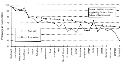
Appendix 3.3: Percentage of Catholic and Protestant households with exclusive
use of a fixed bath or shower, district council areas, 1971
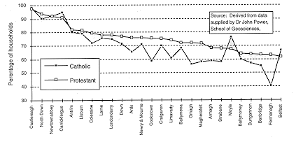
Appendix 3.4: Percentage of Catholic and Protestant households with exclusive
use of an inside toilet, district council areas, 1971
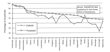
Appendix 3.5: Percentage of Catholic and Protestant households with exclusive
use of hot water, district council areas, 1971
Appendix 3.6:Aspects of housing characteristics, administrative
level, 1971
| Administrative area | % Catholics (based on unadjusted figures)
| Persons per room | % over one person per room
| % dwellings with hot water, fixed bath, and inside WC
| % dwellings with hot water
| % dwellings with fixed bath or shower
| % dwellings with inside toilet (WC)
| Dwellings per 1000 house-holds
| % public renting house- holds
|
| BELFAST CB |
| CLIFTON W | 35.28
| 0.64 | 14.0
| 71.9 | 84.2
| 77.1 | 74.0
| 986.2 | 15.8
|
| COURT W | 32.07
| 0.76 | 20.7
| 31.2 | 53.2
| 34.2 | 35.8
| 998.6 | 40.0
|
| CROMAC W | 26.69
| 0.54 | 8.2
| 56.4 | 71.61
| 60.4 | 59.7
| 963.5 | 7.4
|
| DOCK W | 62.07
| 0.80 | 25.9
| 39.3 | 60.9
| 41.2 | 44.4
| 992.7 | 42.0
|
| DUNCAI RN W | 17.37
| 0.62 | 11.2
| 68.2 | 81.6
| 72.1 | 70.7
| 989.9 | 24.8
|
| FALLS W | 79.56
| 0.96 | 36.1
| 42.8 | 66.6
| 48.9 | 46.4
| 997.1 | 57.1
|
| ORMEAU W | 15.10
| 0.54 | 6.9
| 63.5 | 80.5
| 69.1 | 65.3
| 989.2 | 13.6
|
| POTTINGER W | 11.60
| 0.58 | 9.0
| 57.1 | 74.7
| 61.4 | 59.4
| 994.4 | 14.1
|
| SHANKILL W | 7.82
| 0.68 | 13.8
| 48.3 | 71.2
| 51.9 | 51.6
| 996.8 | 51.7
|
| SMITHFIELD W | 74.94
| 0.86 | 23.8
| 47.6 | 63.7
| 48.4 | 50.9
| 996.8 | 35.5
|
| ST.ANNE'S W | 38.82
| 0.69 | 15.9
| 40.5 | 75.4
| 55.2 | 46.0
| 999.0 | 11.5
|
| ST.GEORGE'S W | 4.12
| 0.69 | 15.4
| 7.3 | 41.4
| 11.0 | 11.5
| 997.6 | 33.1
|
| VICTORIA W | 4.07
| 0.57 | 8.4
| 64.6 | 80.4
| 69.1 | 66.5
| 992.2 | 17.0
|
| WINDSOR W | 16.58
| 0.51 | 6.7
| 67.7 | 80.4
| 72.8 | 69.8
| 961.6 | 13.6
|
| WOODVALE W | 15.62
| 0.74 | 17.4
| 51.3 | 70.4
| 53.6 | 55.2
| 999.0 | 32.8
|
| LONDONDERRY |
| NORTH W | 43.55
| 0.69 | 17.5
| 66.0 | 74.7
| 68.6 | 72.1
| 947.5 | 24.0
|
| SOUTH W | 82.11
| 1.01 | 36.7
| 69.7 | 75.1
| 70.9 | 73.4
| 981.9 | 61.8
|
| WATERSIDE W | 39.81
| 0.77 | 21.5
| 74.6 | 80.4
| 75.5 | 78.7
| 985.9 | 37.5
|
| COLERAINE MB | 21.95
| 0.68 | 13.2
| 84.8 | 90.5
| 85.7 | 86.5
| 993.3 | 48.3
|
| LIMAVADY UD | 32.37
| 0.75 | 15.8
| 92.0 | 93.7
| 92.3 | 93.6
| 993.9 | 66.6
|
| LONDONDERRY UD | 46.65
| 0.83 | 24.6
| 78.5 | 81.3
| 79.0 | 79.9
| 998.2 | 41.8
|
| PORTSTEWART UD | 22.00
| 0.53 | 5.9
| 94.8 | 97.1
| 95.1 | 96.9
| 995.0 | 17.1
|
| COLERAINE RD | 22.96
| 0.76 | 21.6
| 59.1 | 63.8
| 60.2 | 60.9
| 995.5 | 37.4
|
| LIMAVADY RD | 48.45
| 0.94 | 33.3
| 57.8 | 62.0
| 58.7 | 59.7
| 997.7 | 37.1
|
| MAGHERAFELT RD | 43.91
| 0.84 | 26.7
| 63.3 | 68.9
| 64.3 | 65.9
| 998.1 | 33.1
|
| TYRONE |
| COOKSTOWN UD | 34.45
| 0.70 | 15.2
| 90.3 | 91.6
| 90.3 | 93.9
| 998.4 | 46.7
|
| DUNGANNON UD | 41.72
| 0.74 | 19.5
| 88.2 | 91.8
| 89.2 | 89.8
| 985.9 | 53.8
|
| OMAGH UD | 53.55
| 0.73 | 17.3
| 86.2 | 88.9
| 86.6 | 88.9
| 987.1 | 46.6
|
| STRABANE UD | 71.50
| 0.85 | 30.0
| 80.3 | 83.0
| 80.9 | 83.2
| 970.5 | 47.5
|
| CASTLEDERG RD | 44.98
| 0.87 | 31.6
| 39.3 | 43.8
| 39.7 | 42.3
| 997.2 | 22.7
|
| CLOGHER RD | 44.12
| 0.74 | 20.6
| 47.9 | 53.7
| 49.0 | 51.6
| 995.3 | 19.4
|
| COOKSTOWN RD | 44.66
| 0.85 | 27.2
| 51.7 | 58.5
| 52.8 | 54.8
| 997.5 | 21.6
|
| DUNGANNON RD | 43.03
| 0.83 | 25.7
| 55.8 | 63.6
| 57.9 | 57.6
| 998.0 | 31.0
|
| OMAGH RD | 51.25
| 0.84 | 27.4
| 49.7 | 56.3
| 50.8 | 52.5
| 998.4 | 20.5
|
| STRABANE RD | 42.61
| 0.86 | 29.1
| 55.3 | 59.0
| 55.8 | 60.5
| 997.0 | 35.9
|
| FERMANAGH |
| ENNISKILLEN MB | 43.54
| 0.68 | 14.4
| 82.6 | 86.9
| 83.9 | 85,3
| 979.4 | 54.6
|
| ENNISKILLEN RD | 42.63
| 0.74 | 18.8
| 54.5 | 61.2
| 55.4 | 56.7
| 998.2 | 25.7
|
| IRVINESTOWN RD | 47.37
| 0.76 | 22.3
| 46.2 | 52.7
| 47.3 | 49.2
| 998.3 | 19.4
|
| LISNASKEA RD | 54.51
| 0.76 | 23.3
| 34.0 | 39.6
| 34.9 | 36.3
| 996.2 | 16.6
|
| ARMAGH |
| ARMAGH UD | 50.66
| 0.71 | 17.5
| 79.9 | 83.2
| 80.6 | 82.5
| 990.2 | 54.1
|
| CRAIGAVON UD | 34.57
| 0.74 | 17.4
| 60.9 | 66.2
| 62.2 | 62.1
| 998.2 | 44.0
|
| KEADY UD | 78.98
| 0.83 | 24.3
| 85.0 | 87.2
| 85.5 | 89.2
| 1000.0 | 62.9
|
| LURGAN MB | 44.25
| 0.70 | 14.5
| 76.2 | 82.7
| 77.6 | 79.0
| 999.7 | 58.1
|
| PORTADOWN MB | 24.60
| 0.69 | 13.4
| 76.3 | 83.2
| 78.2 | 78.2
| 997.8 | 53.3
|
| TANDRAGEE UD | 16.43
| 0.67 | 13.3
| 91.5 | 94.4
| 92.1 | 94.0
| 994.2 | 62.2
|
| ARMAGH RD | 36.73
| 0.75 | 20.5
| 48.3 | 55.7
| 49.9 | 50.3
| 998.7 | 23.3
|
| NEWRY No.2 RD | 66.96
| 0.85 | 26.7
| 66.4 | 70.6
| 67.3 | 68.5
| 999.5 | 43.8
|
| TANDRAGEE RD | 8.28
| 0.68 | 14.2
| 63.5 | 70.5
| 65.2 | 66.5
| 1000.0 | 23.2
|
(continued below)
Appendix 3.6 Aspects of housing condition, continued
| Administrative area | % Catholics (based on unadjusted figures)
| Persons per room | % over one person per room
| % dwellings with hot water, fixed bath, and inside WC
| % dwellings with hot water
| % dwellings with fixed bath or shower
| % dwellings with inside toilet (WC)
| Dwellings per 1000 house-holds
| % public renting house- holds
|
| DOWN |
| BANBRIDGE UD | 29.44
| 0.69 | 12.8
| 78.2 | 84.2
| 81.8 | 81.1
| 997.9 | 57.5
|
| BANGOR MB | 8.45
| 0.54 | 4.7
| 92.8 | 96.4
| 94.8 | 93.7
| 993.4 | 18.5
|
| DONAGHADEE UD | 5.11
| 0.55 | 6.5
| 82.3 | 90.5
| 83.6 | 84.7
| 999.2 | 34.8
|
| DOWNPATRICK UD | 65.31
| 0.81 | 24.1
| 90.4 | 94.8
| 93.1 | 92.1
| 996.2 | 60.2
|
| DROMOREUD | 15.84
| 0.68 | 13.6
| 62.6 | 67.9
| 63.8 | 66.3
| 998.6 | 46.8
|
| HOLYWOOD UD | 19.73
| 0.59 | 9.3
| 91.5 | 96.1
| 94.1 | 92.4
| 999.6 | 39.3
|
| KILKEEL UD | 20.17
| 0.66 | 13.3
| 86.5 | 90.2
| 86.9 | 91.6
| 998.7 | 29.3
|
| NEWCASTLE UD | 44.79
| 0.60 | 12.0
| 89.7 | 91.3
| 89.9 | 91.4
| 994.2 | 23.1
|
| NEWRYUD | 74.52
| 0.81 | 25.4
| 71.4 | 75.6
| 72.1 | 75.6
| 991.3 | 53.7
|
| NEWTOWNARDS MB | 11.30
| 0.64 | 9.4
| 76.2 | 83.1
| 78.5 | 78.2
| 999.4 | 49.2
|
| WARRENPOINT UD | 68.69
| 0.66 | 15.0
| 91.5 | 93.7
| 91.7 | 93.0
| 994.6 | 47.4
|
| BANBRIDGE RD | 24.80
| 0.73 | 18.8
| 50.0 | 57.7
| 51.3 | 53.2
| 997.7 | 22.8
|
| CASTLEREAGH RD | 7.61
| 0.66 | 8.2
| 98.3 | 99.1
| 98.6 | 98.7
| 999.4 | 45.6
|
| EAST DOWN RD | 42.49
| 0.75 | 20.1
| 66.6 | 73.7
| 67.9 | 69.4
| 998.2 | 31.7
|
| HILLSBOROUGH RD | 8.83
| 0.61 | 7.2
| 82.3 | 86.5
| 83.3 | 84.0
| 999.7 | 25.6
|
| MOIRA RD | 17.58
| 0.66 | 13.0
| 67.6 | 72.4
| 69.8 | 69.3
| 999.2 | 42.4
|
| NEWRY No.l RD | 53.37
| 0.82 | 25.1
| 70.3 | 75.1
| 71.0 | 72.4
| 999.2 | 35.7
|
| NORTH DOWN RD | 14.63
| 0.62 | 10.1
| 71.1 | 76.3
| 72.2 | 73.5
| 998.4 | 36.4
|
| SOUTH DOWN RD | 55.45
| 0.81 | 26.0
| 63.0 | 67.3
| 63.7 | 66.2
| 998.9 | 28.2
|
| ANTRIM |
| BALLYCASTLE UD | 54.61
| 0.68 | 16.7
| 89.8 | 91.8
| 90.2 | 92.5
| 1000.0 | 42.0
|
| BALLYCLARE UD | 5.58
| 0.65 | 9.5
| 76.3 | 82.6
| 78.1 | 78.1
| 1000.0 | 46.3
|
| BALLYMENA MB | 21.29
| 0.65 | 10.9
| 77.5 | 84.1
| 78.8 | 79.6
| 998.9 | 42.2
|
| BALLYMONEY UD | 23.64
| 0.69 | 17.2
| 82.6 | 86.4
| 83.8 | 85.0
| 998.1 | 52.6
|
| CARRICKFERGUS MB | 13.33
| 0.68 | 10.8
| 89.8 | 93.7
| 90.7 | 91.4
| 999.3 | 62.5
|
| LARNE MB | 25.63
| 0.64 | 9.3
| 82.3 | 87.2
| 83.7 | 84.0
| 999.1 | 53.5
|
| LISBURN MB | 18.09
| 0.67 | 10.8
| 85.2 | 89.3
| 86.2 | 88.2
| 999.5 | 44.1
|
| NEWTOWNABBEY UD | 18.57
| 0.67 | 8.9
| 95.6 | 96.9
| 95.9 | 96.4
| 999.1 | 42.6
|
| PORTRUSH UD | 19.19
| 0.54 | 8.0
| 86.6 | 90.5
| 87.2 | 89.9
| 946.5 | 24.2
|
| WHITEHEAD UD | 15.84
| 0.50 | 4.1
| 97.9 | 98.8
| 98.2 | 98.3
| 1000.0 | 32.0
|
| ANTRIM RD | 20.08
| 0.70 | 13.6
| 80.1 | 84.3
| 80.8 | 81.4
| 998.1 | 50.7
|
| BALLYCASTLE RD | 46.19
| 0.77 | 22.9
| 59.8 | 63.6
| 60.5 | 62.8
| 999.1 | 34.8
|
| BALLYMENA RD | 15.17
| 0.70 | 14.3
| 64.8 | 71.5
| 65.8 | 66.8
| 998.5 | 27.1
|
| BALLYMONEY RD | 21.12
| 0.77 | 22.5
| 58.7 | 63.8
| 59.6 | 60.3
| 999.0 | 50.5
|
| LARNE RD | 19.19
| 0.64 | 11.0
| 75.3 | 81.8
| 76.5 | 77.6
| 999.1 | 36.0
|
| LISBURN RD | 37.78
| 0.72 | 15.7
| 89.1 | 91.2
| 89.8 | 90.0
| 999.4 | 43.0
|
Source: 1971 Census County Reports
Appendix 4.1: Unfitness, Amenities and repair, district council
areas., 1974 to 1994
| NIHE Region | District council area
| % of Catholics, 1971 (Compton 1978)
| % of dwellings unfit, 1974
| % of dwellings lacking at least one amenity, 1974
| % of Catholics, 1981 (Compton and Power 1986)
| % of dwellings unfit, 1979
| % of dwellings lacking at least one amenity, 1979
| % of dwellings unfit, 1984
| % of dwellings lacking at least one amenity, 1984
| % of dwellings requiring repairs over £2,500, 1984
|
| | |
| | | |
| | | |
| Belfast | Belfast | 34.1
| 25.0 | 36.3
| 38.0 | 15.1
| 28.6 | 12.1
| 14.2 | 39.1
|
| North East | Ballymoney | 29.6
| 27.3 | 29.2
| 29.0 | 21.4
| 21.8 | 12.6
| 8.9 | 23.1
|
| Moyle | 48.7
| 22.7 | 27.1
| 51.0 | 20.6
| 17.9 | 18.4
| 14.1 | 32.5
|
| Larne | 26.8
| 13.2 | 23.4
| 24.5 | 15.7
| 18.7 | 16.0
| 13.4 | 28.1
|
| Ballymena | 17.7
| 16.5 | 23.2
| 19.0 | 12.8
| 14.2 | 9.5
| 7.6 | 26.7
|
| Antrim | 31.1
| 11.3 | 14.6
| 33.0 | 8.9
| 10.1 | 6.2
| 4.7 | 13.4
|
| Newtownabbey | 18.0
| 7.4 | 6.5
| 13.5 | 3.8
| 5.1 | 2.3
| 1.3 | 10.9
|
| Carrickfergus | 16.2
| 12.0 | 10.5
| 8.0 | 5.5
| 6.5 | 4.6
| 5.2 | 16.2
|
| North West | Derry | 64.3
| 13.0 | 20.7
| 68.5 | 9.4
| 11.6 | 6.7
| 5.2 | 18.2
|
| Limavady | 52.4
| 21.3 | 26.1
| 54.5 | 17.4
| 18.1 | 13.0
| 7.5 | 31.4
|
| Coleraine | 23.9
| 16.5 | 19.9
| 24.0 | 13.9
| 11.0 | 11.1
| 2.7 | 36.9
|
| Magherafelt | 54.7
| 25.4 | 32.6
| 56.5 | 21.6
| 20.8 | 15.5
| 15.0 | 22.8
|
| Strabane | 56.9
| 30.5 | 34.1
| 61.0 | 23.9
| 19.7 | 12.1
| 10.5 | 29.5
|
| South East | Down | 54.1
| 16.8 | 24.8
| 59.5 | 16.2
| 16.4 | 10.8
| 7.9 | 23.8
|
| Lisburn | 16.6
| 16.7 | 17.8
| 22.5 | 11.2
| 10.8 | 7.0
| 6.5 | 18.4
|
| North Down | 11.3
| 5.7 | 6.1
| 9.0 | 5.2
| 3.3 | 3.2
| 2.5 | 19.1
|
| Ards | 16.0
| 12.4 | 26.1
| 13.0 | 11.8
| 16.3 | 8.1
| 7.8 | 17.1
|
| Castlereagh | 10.1
| 1.0 | 2.3
| 8.0 | 1.8
| 1.7 | 1.4
| 1.4 | 14.1
|
| South | Craigavon | 38.7
| 20.0 | 24.4
| 42.0 | 11.1
| 16.4 | 9.0
| 9.0 | 20.6
|
| Armagh | 44.5
| 25.3 | 30.9
| 46.5 | 14.3
| 19.1 | 10.4
| 12.3 | 29.6
|
| Newry & Mourne | 71.4
| 27.2 | 29.6
| 74.0 | 19.3
| 21.2 | 11.5
| 10.2 | 25.6
|
| Banbridge | 31.2
| 20.5 | 34.8
| 28.5 | 21.9
| 25.3 | 19.0
| 13.8 | 37.9
|
| Cookstown | 49.2
| 20.2 | 28.4
| 52.5 | 23.9
| 19.4 | 16.2
| 12.4 | 29.7
|
| Omagh | 62.1
| 33.6 | 37.2
| 65.0 | 21.7
| 24.6 | 18.5
| 13.7 | 32.3
|
| Femanagh | 52.5
| 41.0 | 43.0
| 54.5 | 31.0
| 24.6 | 27.0
| 16.0 | 36.5
|
| Dungannon | 52.3
| 28.1 | 34.5
| 53.0 | 21.0
| 23.2 | 15.3
| 9.3 | 30.0
|
| Northern Ireland | . | 36.8
| 19.6 | 26.2
| 38.5 | 14.1
| 17.9 | 10.4
| 9.2 | 26.7
|
Source: NIHE (1 974, 19820 1985), Compton (1978) and Compton
and Power (1986)
Appendix 5.1: Aspects of housing characteristics, district
council areas, 1981
| Councils | % Catholics 1981(based on Compton and Power 1986 adjustments)
| Number of private households
| % dwellings owner-occupied
| % dwellings public rented |
Average number of persons per room
| % house-holds living at a density of more than 1.0 persons per room
|
| Antrim | 33.0
| 12546 | 33.73
| 57.61 | 0.66
| 10.3 |
| Ards | 13.0
| 18813 | 50.51
| 39.83 | 0.59
| 6.3 |
| Armagh | 46.5
| 13589 | 55.54
| 37.57 | 0.65
| 12.5 |
| Ballymena | 19.0
| 16758 | 52.52
| 40.62 | 0.60
| 7.7 |
| Ballymoney | 29.0
| 6609 | 42.31
| 51.69 | 0.67
| 14.5 |
| Banbridge | 28.5
| 9086 | 51.32
| 40.87 | 0.64
| 10.6 |
| Belfast | 38.0
| 102863 | 50.12
| 32.05 | 0.57
| 9.0 |
| Carrickfergus | 8.0
| 9205 | 38.76
| 53.74 | 0.58
| 5.3 |
| Castlereagh | 8.0
| 19935 | 52.89
| 42.65 | 0.58
| 4.6 |
| Coleraine | 24.0
| 14392 | 48.94
| 42.24 | 0.59
| 9.0 |
| Cookstown | 52.5
| 7359 | 59.34
| 32.02 | 0.69
| 15.9 |
| Craigavon | 42.0
| 21674 | 38.94
| 52.45 | 0.63
| 10.1 |
| Down | 59.5
| 15026 | 51.04
| 38.45 | 0.66
| 13.2 |
| Dungannon | 53.0
| 11667 | 54.32
| 37.10 | 0.68
| 16.2 |
| Fermanagh | 54.5
| 14618 | 59.37
| 32.25 | 0.65
| 13.9 |
| Larne | 24.5
| 9284 | 49.20
| 40.65 | 0.58
| 7.1 |
| Limavady | 54.5
| 6869 | 39.23
| 49.69 | 0.75
| 18,9 |
| Lisburn | 22.5
| 25373 | 49.90
| 41.59 | 0.60
| 6.8 |
| Derry | 68.5
| 21870 | 39.71
| 54.82 | 0.74
| 18.6 |
| Magherafelt | 56.5
| 8385 | 54.41
| 37.13 | 0.73
| 18.4 |
| Moyle | 51.0
| 4118 | 47.67
| 43.78 | 0.66
| 15.4 |
| Newry & Mourne | 74.0
| 20141 | 44.03
| 49.90 | 0.71
| 16.4 |
| Newtownabbey | 13.5
| 23297 | 45.95
| 44.31 | 0.60
| 5.5 |
| North Down | 9.0
| 22479 | 66.92
| 23.72 | 0.52
| 2.9 |
| Omagh | 65.0
| 11011 | 55.98
| 35.24 | 0.70
| 16.4 |
| Strabane | 61.0
| 9381 | 42.22
| 48.42 | 0.75
| 20.8 |
| Northern Ireland | 38.5
| 456348 | 49.44
| 40.23 | 0.62
| 10.4 |
Source: 1981 Census Summary Report
Appendix 5.1 Continued
| Councils | % dwellings with exclusive use of fixed bath
| % dwellings with exclusive use of inside WC
| % dwellings connected to public water supply
| % dwellings connected to public sewer
| house-holds with central heating
|
| Antrim | 94.8
| 95.4 | 95.1
| 76.8 | 61.25
|
| Ards | 91.2
| 92.1 | 99.0
| 81.1 | 49.22
|
| Armagh | 89.6
| 90.5 | 95.7
| 61.9 | 43.64
|
| Ballymena | 92.0
| 92.7 | 89.9
| 74.4 | 50.19
|
| Ballymoney | 88.0
| 88.8 | 90.4
| 61.9 | 34.30
|
| Banbridge | 88.6
| 89.2 | 95.0
| 61.5 | 42.41
|
| Belfast | 83.7
| 83.9 | 99.7
| 99.5 | 31.79
|
| Carrickfergus | 96.0
| 96.5 | 98.2
| 94.7 | 43.92
|
| Castlereagh | 98.5
| 98.7 | 99.6
| 95.8 | 60.33
|
| Coleraine | 94.0
| 94.7 | 95.5
| 81.8 | 50.06
|
| Cookstown | 89.5
| 90.6 | 94.0
| 55.9 | 37.99
|
| Craigavon | 92.2
| 92.9 | 98.2
| 85.1 | 51.77
|
| Down | 91.6
| 92.8 | 96.1
| 68.4 | 48.95
|
| Dungannon | 87.5
| 88.4 | 91.9
| 58.5 | 34.00
|
| Fermanagh | 8113
| 82.5 | 87.0
| 49.9 | 37.60
|
| Larne | 91.2
| 92.0 | 91.0
| 81.5 | 36.99
|
| Limavady | 93.2
| 94.1 | 93.7
| 72.3 | 48.78
|
| Lisburn | 94.7
| 95.4 | 97.3
| 81.9 | 56.32
|
| Derry | 95.1
| 96.1 | 98.0
| 91.4 | 50.43
|
| Magherafelt | 87.5
| 88.9 | 89.3
| 53.8 | 32.90
|
| Moyle | 89.1
| 90.6 | 88.8
| 61.8 | 30.04
|
| Newry & Mourne | 91.3
| 92.6 | 95.7
| 71.7 | 35.73
|
| Newtownabbey | 97.5
| 98.1 | 98.5
| 94.4 | 57.25
|
| North Down | 98.0
| 97.7 | 99.8
| 97.2 | 62.02
|
| Omagh | 86.5
| 87.7 | 84.0
| 56.4 | 43.01
|
| Strabane | 86.4
| 88.6 | 85.8
| 63.6 | 36.12
|
| Northern Ireland | 90.4
| 91.1 | 96.1
| 82.2 | 44.47
|
Source: 1981 Census Summary Report
Appendix 5.2: Amenity provision by religion, district council
areas 1981
| Councils | %Catholic households with fixed bath or shower
| % Protestant households with fixed bath or shower
| % Catholic households with inside toilet (WC)
| % Protestant households with inside toilet (WC)
| % Catholic households connected to public water supply
| % Protestant households connected to public water supply
| % Catholic households connected to public sewer
| % Protestant households connected to public sewer
|
| Antrim | 94.8
| 94.4 | 95.7
| 94.9 | 97.3
| 94.0 | 79.0
| 74.7 |
| Ards | 87.9 |
91.4 | 89.3
| 92.2 | 98.4
| 99.1 | 75.3
| 81.7 |
| Armagh | 88.0
| 90.6 | 89.3
| 91.1 | 95.5
| 95.9 | 64.2
| 59.3 |
| Ballymena | 91.6
| 92.1 | 92.5
| 92.7 | 90.8
| 89.7 | 75.8
| 74.1 |
| Ballymoney | 87.9
| 88.0 | 89.0
| 88.8 | 89.0
| 90.7 | 59.1
| 61.7 |
| Banbridge | 88.3
| 89.0 | 89.1
| 89.5 | 93.9
| 95.4 | 62.8
| 61.4 |
| Belfast | 87.1
| 81.9 | 88.2
| 81.7 | 99.7
| 99.8 | 99.4
| 99.5 |
| Carrickfergus | 96.1
| 96.0 | 96.5
| 96.4 | 98.9
| 98.1 | 96.7
| 94.4 |
| Castlereagh | 97.6
| 98.4 | 97.6
| 98.7 | 99.7
| 99.6 | 98.5
| 95.6 |
| Coleraine | 93.3
| 94.1 | 93.9
| 94.9 | 93.3
| 96.0 | 80.5
| 82.0 |
| Cookstown | 88.0
| 91.4 | 89.7
| 92.0 | 93.2
| 95.5 | 53.8
| 58.8 |
| Craigavon | 91.6
| 92.4 | 92.9
| 92.8 | 98.2
| 98.2 | 85.2
| 84.3 |
| Down | 92.1 |
91.5 | 93.5
| 92.6 | 96.5
| 95.9 | 71.4
| 61.9 |
| Dungannon | 86.7
| 88.0 | 88.3
| 88.5 | 91.5
| 92.1 | 61.2
| 56.1 |
| Fermanagh | 76.1
| 86.6 | 74.4
| 87.6 | 83.0
| 90.9 | 19.4
| 49.6 |
| Larne | 90.7
| 91.3 | 92.3
| 92.0 | 91.3
| 90.8 | 88.1
| 79.7 |
| Limavady | 92.2
| 94.6 | 93.4
| 95.3 | 93.7
| 94.2 | 76.3
| 69.6 |
| Lisburn | 95.0
| 94.5 | 95.1
| 95.3 | 97.5
| 97.3 | 86.3
| 80.6 |
| Londonderry | 95.2
| 95.2 | 96.5
| 96.0 | 98.4
| 97.7 | 93.6
| 88.1 |
| Magheratelt | 86.7
| 89.0 | 87.9
| 90.0 | 86.1
| 93.1 | 51.7
| 57.6 |
| Moyle | 90.7
| 87.1 | 92.3
| 88.6 | 87.5
| 89.9 | 65.7
| 55.6 |
| Newry & Mourne | 91.6
| 90.8 | 92.9
| 91.9 | 95.3
| 96.7 | 73.0
| 67.8 |
| Newtownabbey | 96.0
| 97.6 | 97.2
| 98.1 | 99.4
| 98.3 | 98.9
| 93.7 |
| North Down | 96.5
| 98.1 | 96.5
| 97.9 | 99.8
| 99.8 | 98.3
| 97.1 |
| Omagh | 84.6
| 89.7 | 86.2
| 90.5 | 83.3
| 85.6 | 57.6
| 55.3 |
| Strabane | 85.4
| 87.6 | 88.0
| 89.5 | 85.4
| 85.8 | 71.8
| 52.1 |
| Northern Ireland | 89.4
| 90.7 | 90.6
| 91.2 | 94.6
| 96.8 | 78.9
| 83.3 |
Source: 1981 Census Religion Report
Appendix 9.1: Aspects of household characteristics, district
council areas, 1991
| District council area | % Catholics in area (no adjustment)
| % households owner-occupied
| % households public rented
| Average number of persons per room
| % households more than 1.0 person per room
|
| Antrim | 31.71
| 59.23 | 34.44
| 0.54 | 4.3
|
| Ards | 11.34
| 67.35 | 26.49
| 0.51 | 2.5
|
| Armagh | 45.39
| 68.54 | 25.46
| 0.56 | 6.7
|
| Ballymena | 18.35
| 65.93 | 28.45
| 0.51 | 3.2
|
| Ballymoney | 30.21
| 57.84 | 37.27
| 0.55 | 6.3
|
| Banbridge | 27.64
| 65.94 | 28.49
| 0.54 | 4.4
|
| Belfast | 39.02
| 54.11 | 36.19
| 0.49 | 3.7
|
| Carrickfergus | 6.93
| 64.50 | 31.07
| 0.49 | 1.7
|
| Castlereagh | 9.45
| 68.97 | 28.47
| 0.48 | 1.4
|
| Coleraine | 22.45
| 59.66 | 31.80
| 0.49 | 3.0
|
| Cookstown | 53.16
| 68.93 | 24.34
| 0.59 | 8.1
|
| Craigavon | 40.09
| 61.93 | 32.09
| 0.54 | 4.5
|
| Derry | 69.48
| 50.62 | 44.83
| 0.62 | 9.7
|
| Down | 56.04
| 66.40 | 25.46
| 0.55 | 6.2
|
| Dungannon | 55.69
| 66.67 | 25.64
| 0.58 | 8.1
|
| Fermanagh | 54.89
| 67.87 | 24.54
| 0.55 | 6.8
|
| Larne | 22.13
| 68.04 | 26.16
| 0.49 | 2.4
|
| Limavady | 51.68
| 56.16 | 34.86
| 0.62 | 9.1
|
| Lisburn | 26.93
| 61.90 | 32.76
| 0.52 | 3.2
|
| Magherafelt | 58.90
| 66.01 | 26.56
| 0.61 | 9.6
|
| Moyle | 52.22
| 58.04 | 34.02
| 0.55 | 6.5
|
| Newry & Mourne | 71.81
| 64.15 | 29.91
| 0.60 | 8.9
|
| Newtownabbey | 13.01
| 66.62 | 28.82
| 0.51 | 2.1
|
| North Down | 8.96
| 77.03 | 17.01
| 0.46 | 1.3
|
| Omagh | 64.33
| 65.91 | 25.96
| 0.58 | 8.3
|
| Strabane | 61.81
| 54.43 | 38.48
| 0.61 | 10.4
|
| | |
| | |
| Northern Ireland | 38.38
| 62.26 | 30.96
| 0.53 | 4.8
|
Source: 1991 Census Summary and Religion Reports
Appendix 9.1 Continued
| District council area | % house-holds with exclusive use of fixed bath or shower
| % house-holds with exclusive use of inside WC
| % house-holds with central heating in all or some rooms
| % house-holds connected to public water supply
| % house-holds connected to public sewer
| % house-holds employed in farming
| % house- holds with two or more cars
|
| Antrim | 98.4
| 98.8 | 85.0
| 97.5 | 74.5
| 8.13 | 23.34
|
| Ards | 98.1
| 98.5 | 82.0
| 99.7 | 82.5
| 6.60 | 26.83
|
| Armagh | 97.0
| 97.6 | 80.7
| 98.8 | 63.5
| 18.84 | 24.89
|
| Ballymena | 97.9
| 98.2 | 80.1
| 95.9 | 74.9
| 11.27 | 24.23
|
| Ballymoney | 97.8
| 98.1 | 72.1
| 96.4 | 65.2
| 18.49 | 22.55
|
| Banbridge | 97.4
| 97.9 | 82.3
| 98.7 | 64.2
| 16.02 | 27.39
|
| Belfast | 97.7
| 98.0 | 82.0
| 99.9 | 98.6
| 0.21 | 11.23
|
| Carrickfergus | 99.2
| 99.4 | 81.4
| 98.9 | 94.8
| 1.20 | 21.34
|
| Castlereagh | 99.7
| 99.8 | 92.5
| 99.9 | 95.7
| 1.47 | 23.69
|
| Coleraine | 98.6
| 99.1 | 81.2
| 98.5 | 83.7
| 8.78 | 19.42
|
| Cookstown | 97.2
| 97.9 | 75.8
| 98.3 | 56.4
| 20.91 | 23.25
|
| Craigavon | 98.5
| 98.8 | 88.3
| 99.5 | 86.1
| 5.29 | 19.15
|
| Derry | 98.8
| 99.2 | 87.3
| 99.5 | 92.5
| 3.48 | 12.42
|
| Down | 97.6
| 98.3 | 81.5
| 98.8 | 70.3
| 12.14 | 25.59
|
| Dungannon | 96.6
| 97.3 | 76.3
| 97.4 | 59.4
| 21.20 | 23.04
|
| Fermanagh | 94.6
| 95.4 | 76.6
| 96.3 | 54.2
| 29.82 | 21.91
|
| Larne | 97.6
| 98.0 | 72.4
| 95.4 | 81.0
| 7.68 | 20.11
|
| Limavady | 98.2
| 98.5 | 83.7
| 98.1 | 74.5
| 13.63 | 18.53
|
| Lisburn | 98.8
| 99.2 | 87.7
| 99.5 | 83.9
| 4.78 | 25.18
|
| Magherafelt | 96.5
| 97.0 | 74.3
| 96.4 | 55.5
| 20.23 | 23.97
|
| Moyle | 96.7
| 97.2 | 70.7
| 94.8 | 65.6
| 21.78 | 16.88
|
| Newry & Mourne | 97.5
| 97.9 | 79.5
| 98.4 | 71.2
| 13.55 | 19.44
|
| Newtownabbey | 99.3
| 99.6 | 87.0
| 99.6 | 93.4
| 1.91 | 20.91
|
| North Down | 99.1
| 99.4 | 88.5
| 99.9 | 97.4
| 0.98 | 27.32
|
| Omagh | 96.8
| 97.5 | 84.2
| 95.2 | 58.2
| 24.27 | 21.08
|
| Strabane | 96.0
| 97.0 | 74.7
| 94.6 | 66.1
| 21.48 | 16.41
|
| Northern Ireland | 98.0
| 98.4 | 82.7
| 98.6 | 82.4
| 8.28 | 19.90
|
Source: 1991 Census Summary and Religion Reports
Appendix 9.2 Amenity provision by religion, district council
areas, 1991
| District Council areas | % Catholic households with fixed bath or shower
| % Protestant households with fixed bath or shower
| % Catholic households with inside toilet (WC)
| % Protestant households with inside toilet (WC)
| % Catholic households connected to public water supply
| % Protestant households connected to public water supply
| % Catholic households connected to public sewer
| % Protestant households connected to public sewer
| % Catholic households with central heating in all or some rooms
| % Protestant households with central heating in all or some rooms
|
| Antrim | 98.7
| 98.1 | 99.0
| 98.5 | 99.2
| 96.6 | 75.6
| 72.7 | 76.2
| 70.3 |
| Ards | 98.1 |
98.1 | 98.5
| 98.4 | 99.6
| 99.7 | 76.0
| 83.3 | 67.8
| 72.3 |
| Amagh | 97.1
| 97.0 | 97.6
| 97.6 | 98.8
| 98.8 | 65.0
| 61.5 | 71.9
| 69.0 |
| Ballynena | 98.5
| 97.8 | 98.9
| 98.3 | 96.2
| 95.7 | 71.1
| 74.6 | 71.4
| 69.4 |
| Ballymoney | 98.0
| 97.8 | 98.0
| 98.2 | 95.6
| 96.8 | 60.1
| 66.7 | 57.3
| 59.5 |
| Banbridge | 97.1
| 97.3 | 97.7
| 97.8 | 98.3
| 98.7 | 65.0
| 63.3 | 76.0
| 72.4 |
| Belfast | 98.0
| 97.5 | 98.5
| 97.6 | 99.7
| 99.9 | 98.2
| 98.8 | 74.9
| 67.5 |
| Carrickfergus | 99.1
| 99.2 | 99.3
| 99.4 | 99.6
| 98.8 | 96.7
| 94.6 | 65.0
| 69.6 |
| Castlereagh | 99.8
| 99.6 | 99.8
| 99.8 | 100.0
| 99.9 | 97.3
| 95.6 | 90.3
| 80.3 |
| Coleraine | 98.4
| 98.7 | 98.8
| 99.2 | 97.1
| 98.8 | 80.2
| 83.9 | 66.4
| 71.7 |
| Cookstown | 97.1
| 97.3 | 98.0
| 97.8 | 98.0
| 98.5 | 51.8
| 59.7 | 68.5
| 63.2 |
| Craigavon | 98.5
| 98.5 | 98.8
| 98.8 | 99.6
| 99.4 | 86.5
| 85.8 | 81.0
| 76.9 |
| Derry | 99.0
| 98.6 | 99.3
| 99.0 | 99.6
| 99.4 | 94.1
| 89.0 | 80.9
| 82.3 |
| Down | 97.6 |
97.6 | 98.3
| 98.3 | 99.0
| 98.7 | 75.4
| 63.6 | 69.6
| 68.8 |
| Dungannon | 97.0
| 96.4 | 97.5
| 97.1 | 97.5
| 97.4 | 61.5
| 56.1 | 70.0
| 64.2 |
| Femanagh | 93.7
| 95.8 | 94.6
| 96.5 | 95.4
| 97.3 | 54.2
| 53.3 | 65.1
| 67.0 |
| Larne | 97.4
| 97.4 | 97.9
| 97.9 | 95.1
| 95.5 | 88.4
| 79.1 | 57.4
| 64.0 |
| Limavady | 97.9
| 98.6 | 98.3
| 98.7 | 97.9
| 98.2 | 75.6
| 73.2 | 72.3
| 79.7 |
| Lisburn | 99.2
| 98.7 | 99.5
| 99.1 | 99.6
| 99.5 | 89.9
| 81.9 | 87.0
| 78.9 |
| Magherafelt | 96.3
| 96.8 | 96.9
| 97.0 | 95.5
| 97.4 | 51.0
| 60.4 | 65.7
| 61.4 |
| Moyle | 97.1
| 96.2 | 97.4
| 97.0 | 93.8
| 95.6 | 69.9
| 60.9 | 61.7
| 52.1 |
| Newry & Mourne | 97.6
| 97.3 | 98.1
| 97.7 | 98.3
| 98.8 | 72.2
| 67.0 | 72.1
| 65.4 |
| Newtowabbey | 99.6
| 99.3 | 99.7
| 99.5 | 99.9
| 99.5 | 97.1
| 92.7 | 82.4
| 77.1 |
| North Down | 99.0
| 99.3 | 99.2
| 99.5 | 100.0
| 99.9 | 98.4
| 97.3 | 76.9
| 78.4 |
| Omagh | 96.5
| 97.2 | 97.2
| 97.7 | 94.9
| 95.4 | 59.1
| 56.9 | 75.8
| 75.0 |
| Strabane | 95.7
| 96.3 | 96.7
| 97.3 | 95.1
| 94.0 | 74.3
| 52.9 | 67.4
| 62.2 |
| | |
| | | |
| | | |
| Northern Ireland | 97.7
| 98.1 | 98.2
| 98.4 | 98.3
| 98.8 | 79.4
| 83.2 | 73.7
| 71.8 |
Source: 1991 Census Religion Report, Table 8
Appendix 9.3 Aspects of housing condition, district council
areas, 1991
| District council area | % Catholics in area
| % of dwellings Unfit |
% of dwellings lacking at least one amenity
| % dwellings with repair costs over £3000
|
| Antrim | 31.71
| 7.7 | 2.6
| 8.21 |
| Ards | 11.34
| 6.0 | 2.4
| 7.46 |
| Armagh | 45.39
| 11.6 | 3.8
| 7.49 |
| Ballymena | 18.35
| 6.8 | 2.5
| 10.39 |
| Ballymoney | 30.21
| 11.6 | 3.7
| 13.09 |
| Banbridge | 27.64
| 11.4 | 4.8
| 14.35 |
| Belfast | 39.02
| 8.3 | 3.2
| 8.82 |
| Carrickfergus | 6.93
| 2.8 | 1.0
| 9.38 |
| Castlereagh | 9.45
| 2.5 | 0.7
| 2.85 |
| Coleraine | 22.45
| 10.2 | 1.8
| 11.02 |
| Cookstown | 53.16
| 13.6 | 6.2
| 16.68 |
| Craigavon | 40.09
| 3.7 | 0.7
| 6.04 |
| Derry | 69.48
| 7.0 | 1.9
| 11.20 |
| Down | 56.04
| 15.0 | 3.1
| 19.87 |
| Dungannon | 55.69
| 13.7 | 5.1
| 10.42 |
| Fermanagh | 54.89
| 23.3 | 10.2
| 21.43 |
| Larne | 22.13
| 9.0 | 5.8
| 12.66 |
| Limavady | 51.68
| 11.2 | 6.3
| 12.61 |
| Lisburn | 26.93
| 3.4 | 2.4
| 3.86 |
| Magherafelt | 58.90
| 17.8 | 9.1
| 19.89 |
| Moyle | 52.22
| 17.5 | 7.7
| 21.12 |
| Newry & Mourne | 71.81
| 15.2 | 5.0
| 22.28 |
| Newtownabbey | 13.01
| 3.3 | 1.7
| 4.55 |
| North Down | 8.96
| 4.0 | 1.0
| 6.47 |
| Omagh | 64.33
| 12.2 | 6.2
| 9.51 |
| Strabane | 61.81
| 12.8 | 5.2
| 10.14 |
| | |
| |
| Northern Ireland | 38.38
| 8.8 | 3.3
| 10.23 |
Source: 1991 House Condition Report
Return to publication contents
© CCRU 1998-1999
site developed by: Martin Melaugh
page last modified:
Back to the top of this page
|
|